


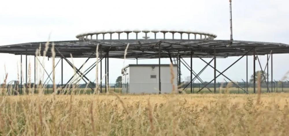
Drehfunkfeuer um 1985
English version below
Orientierung in der Luft – das Drehfunkfeuer in Schnackenburg
Wer zwischen Schnackenburg, Kapern und Holtorf unterwegs ist, kann diese auf den ersten Blick merkwürdig anmutende Anlage auf einem umzäunten Feld entdecken: mehrere Antennen, kreisförmig angeordnet, auf einer Metallfläche montiert. Was aussieht wie eine futuristische Installation, ist tatsächlich ein unscheinbarer, aber wichtiger Bestandteil der zivilen Luftfahrtnavigation – das Drehfunkfeuer mit der Kennung DVOR/DME BKD.
Ein „Leuchtturm“ für Flugzeuge
Das Drehfunkfeuer sendet UKW-Funksignale aus, die von Flugzeugen empfangen werden. Diese Signale helfen den Piloten, ihre genaue Position zu bestimmen und sicher Kurs zu halten – ganz ähnlich, wie sich Schiffe früher an Leuchttürmen orientierten.
Das System funktioniert so: Das Funkfeuer sendet gleichzeitig ein Referenzsignal und ein rotierendes Richtungssignal. Aus dem Zeitunterschied zwischen beiden berechnet das Flugzeug, aus welcher Richtung es das Signal empfängt. So kann der Pilot feststellen, ob er sich z. B. genau nördlich oder südöstlich der Station befindet.
Was bedeutet DVOR/DME?
Das Drehfunkfeuer in Schnackenburg ist ein sogenanntes DVOR/DME:
- DVOR steht für Doppler Very High Frequency Omnidirectional Range und ist ein Funkortungsverfahren. Diese modernere Variante des klassischen VOR nutzt den sogenannten Doppler-Effekt, was sie präziser macht und mögliche Richtungsfehler weitestgehend reduziert.
- DME bedeutet Distance Measuring Equipment – also ein Entfernungsmesssystem. Es zeigt dem Piloten an, wie weit das Flugzeug in schräger Linie von der Bodenstation entfernt ist.
Kombiniert liefern beide Systeme also Richtung und Entfernung – die Grundlage für eine genaue Positionsbestimmung, auch ohne GPS.
Technische Daten und Standort
Die Station trägt das internationale Rufzeichen BKD und sendet auf der Frequenz 117,70 MHz. Das Gelände ist etwa 40 × 40 Meter groß, und der Antennenkranz mit rund 13,5 Metern Durchmesser ist auf einer metallischen Fläche installiert. Diese Konstruktion sorgt dafür, dass das Signal stabil und präzise ausgestrahlt wird.
Warum solche Anlagen noch wichtig sind
Obwohl heute viele Flugzeuge mit Satellitennavigation (GPS) fliegen, bleibt das Netz aus VOR- und DVOR-Stationen weiterhin wichtig. Es dient als Backup-System, falls die Satellitennavigation einmal ausfallen sollte.
Das Drehfunkfeuer in Schnackenburg trägt somit seit den 1980er Jahren zur Sicherheit des Luftverkehrs bei. In Deutschland gibt es noch ein Grundnetz aus rund 50 Stationen.
© 2026 Stephan Prieß
Orientation in the air – the rotating radio beacon in Schnackenburg
Anyone traveling between Schnackenburg, Kapern and Holtorf can discover this seemingly strange system in a fenced field at first glance: several antennas, arranged in a circle, mounted on a metal surface. What looks like a futuristic installation is actually an inconspicuous but important part of civil aviation navigation - the rotary radio beacon with the identification DVOR/DME BKD.
A “lighthouse” for aircraft
The rotary beacon sends out VHF radio signals that are received by aircraft. These signals help the pilots to determine their exact position and to stay safely on course - in much the same way that ships used to orientate themselves using lighthouses.
The system works like this: The radio beacon simultaneously sends a reference signal and a rotating directional signal. The aircraft uses the time difference between the two to calculate from which direction it will receive the signal. This way the pilot can determine whether he is, for example, B. is located exactly north or southeast of the station.
What does DVOR/DME mean?
The rotating radio beacon in Schnackenburg is a so-called DVOR/DME:
- DVOR stands for Doppler Very High Frequency Omnidirectional Range and is a radio positioning method. This more modern version of the classic VOR uses the so-called Doppler effect, which makes it more precise and largely reduces possible directional errors.
- DME stands for Distance Measuring Equipment – a distance measuring system. It shows the pilot how far the aircraft is in a diagonal line from the ground station.
Combined, both systems provide direction and distance - the basis for precise positioning, even without GPS.
Technical data and location
The station has the international call sign BKD and broadcasts on the frequency 117.70 MHz. The area is approximately 40 × 40 meters in size, and the antenna ring with a diameter of around 13.5 meters is installed on a metal surface. This design ensures that the signal is transmitted stably and precisely.
Why such systems are still important
Although many aircraft today fly with satellite navigation (GPS), the network of VOR and DVOR stations remains important. It serves as a backup system should satellite navigation fail.
The rotary radio beacon in Schnackenburg has contributed to air traffic safety since the 1980s. In Germany there is still a basic network of around 50 stations.
© 2026 Stephan Prieß
| Ort | Schnackenburg |
| Autor | Stephan |
| Kategorien | Schule/Bildung Straße/Verkehr |
| Suchbegriffe / Tags | |
| Lizenz | Alle Rechte vorbehalten |
| Bildquelle | Elbe-Jeetzel-Zeitung |
| Urheber | Unbekannt |